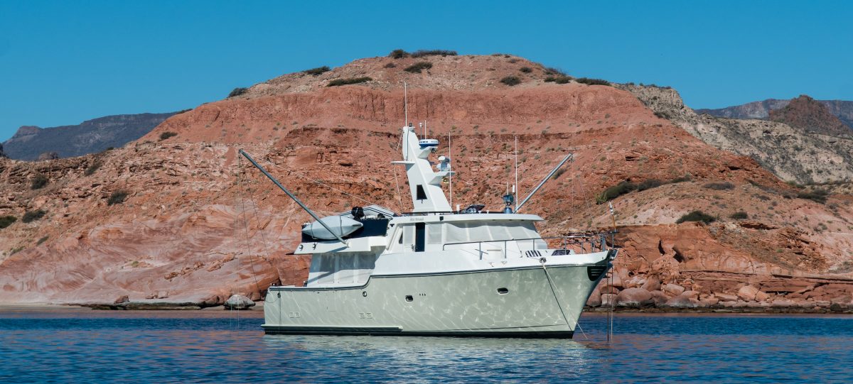
From Puerto Los Cabos to Ensenada is a 700 mile journey around the notorious Cabo Falso, then heading northwest along the Pacific coast, straight into the prevailing winds and seas. There is a good reason that this is called the “Baja Bash”, as we learned this past week. We had been waiting in Puerto Los Cabos for over two weeks to find a suitable weather window to make the trip. Finally, Bob Jones of Ocean Marine Navigation told us that there was a window opening on Memorial Day and potentially lasting the entire first week of June, which would be enough time to make a 100 hour passage all the way to Ensenada.
There was some possibility of less than optimal conditions over the first couple of days, but the forecast improved further up the coast. Part of the reason for this window was the formation of a tropical low pressure system well to the South that eventually became Tropical Storm Blanca. As Bob explained it, this low pressure system weakened the normal gradient between the high pressure system that tends to sit off the Baja Coast and the low pressure trough South and East. This pressure gradient causes almost constant NW winds off the coast, which can build to 20+ knots in the afternoon and create unpleasant conditions. By this time, we were ready to go, having learned not to pass up on decent weather window for a perfect weather window that might never happen.
We departed at 5 AM on Memorial Day, which would allow us to round Cabo Falso just after sunrise, hopefully minimizing the often challenging conditions. As it turned out, we timed it well, and rounded the cape in pretty thick fog, but relatively mild winds and seas. After a few hours we seemed to have broken out of the cape effect and had much reduced head seas. After 28 hours or so, we passed Magdelena Bay, which was the first option for a rest stop. We were making good progress and wanted to press on, knowing that if we stopped, the weather conditions would deteriorate due to swell from the tropical storm.
We rounded Cabo San Lazaro just north of Magdalena Bay, and then crossed the very large Bahia San Lazaro, with the next opportunity to stop at Turtle Bay, some 230 miles to the North. On this second day, conditions began to deteriorate, with the wind picking up in the early evening, getting into the 15-20 knot range and creating short, steep head seas that caused a constant pitching motion and pretty frequent slamming as the bulbous bow came out of the water going over the tops of waves and hitting hard in the troughs.
Unfortunately Gwen had the 4 hour watch during this stretch, and when I came to take over at 2 AM, she was looking quite green in spite of having taken her seasickness medication.
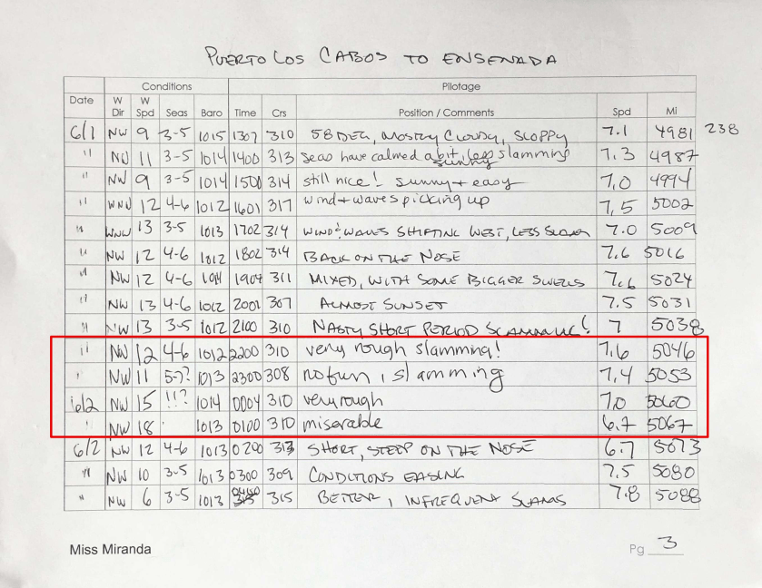
Above is a page from our voyage log on Tuesday night. I have highlighted Gwen’s entries from that fateful night. You can also see that as soon as I came on, conditions started to improve. Sorry, honey. After Gwen discharged the contents of her stomach she got a little bit of sleep, and we decided in the morning to make a stop at Turtle Bay, which was only a few hours away.
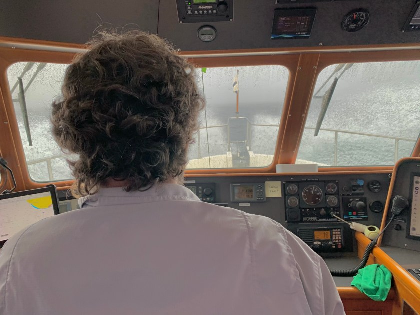
When I came on watch at 10pm that night, the boat was pitching and slamming a fair amount, but Larry said “It should calm down and get better, sorry it’s bad right now.” I took a half of a Gravol (Canadian seasickness medication that I like) – I had taken it regularly the day before and the wisdom is that usually on the second day you can wean off of it. I watched the wind go up instead of down, seeing 20 knots a few times, after which I could sense the waves getting worse. In the second hour, I started to feel pretty bad. I did all the things that one is supposed to – have fresh air blowing directly on you, sip water and take in small amounts of carbs – pretzels, in my case; actively manage the boat – I found sitting in the helm chair to make me feel worse, and standing and rocking with the movement of the boat to help. The big recommended thing that proved difficult to do was to watch the horizon. It was pitch dark with no moon and with spray and, at times, green water, hitting the windshield, and the only way I could keep my eye on something stable was to look at the few visible stars that I could see through the top of the port side corner window. I took more Gravol, no longer worrying that it might make me too sleepy – no danger of that. My last two hours were spent standing there, eyes glued to the stars (except for when we pitched down into a wave trough), and every 15 minutes taking a glance at the radar to ensure we were still all alone out here. I was never scared, because I knew the conditions were nothing the boat couldn’t handle, it was just bad for the human. Once Larry relieved me, and I moved around a bit, everything came rushing up. This, at least, made it possible for me to sleep for a bit.
Gwen’s Perspective
We got into Turtle Bay around 2 PM on Wednesday, June 2nd. This was a good time to stop regardless, as the winds were up into the 20 knot range by this time in the afternoon. Conditions were forecast to be much better in the morning. We anchored just inside the bay, set out the flopper stopper, had a meal, and a good night’s sleep. This first leg wound up covering 420 NM in 57 hours, for an average speed of just under 7.4 knots and fuel economy of 1.37 NMPG at 1700 RPM. We were pushing into adverse current most of the way, and this combined with the head seas made for a slower, less efficient passage.
We headed out at dawn on Thursday morning. This final leg to Ensenada started with rounding Punta Eugenia (named after Gwen’s mother), and crossing Bahia Vizcaino. This is often the most difficult leg of the passage with the open bay and potential convergence zone off Cedros Island. We followed the advice of our friend and Nordhavn Broker/Delivery Captain Devin Zwick and took the “inside” route, passing through the Canal de Dewey and East of Isla Cedros.

As we continued along, we had an unusual visit from a seagull. It was flying above the boat and made many passes across the bow, seemingly interested in the burgee staff. It came closer and closer on each pass, and finally, on one pass… it tried to take a bite out of the top of the staff.

As you can see from the photo, conditions were much improved on this leg. As predicted, winds were well under 10 knots and seas nearly flat calm. Gwen had an uneventful night watch and the next morning we had calm winds and pretty flat seas, with overcast skies and temperatures in the high 50s. I spotted several Gray whales off Punta Colnett, and we had several visits from groups of Pacific White Sided dolphins. One was playing in the bow wake, and as we were watching from the foredeck, flipped over, swam upside down and seemed to look right at us as if saying “I’ll bet you wish you could do this”.
We could soon see the Todos Santos Islands off Ensenada and by mid afternoon we arrived at Marina Coral. We bumped up our speed on this leg, setting the throttle for 1800 RPM. As a result, we covered the 280 miles in 35 hours for an average speed of 8 knots and a fuel economy of 1.3 NMPG. We were happy to trade a little more fuel burn for saving a couple of hours of travel time.
The only boat-related issue we had was a problem with our drinking water. We have a separate drinking water supply with a dedicated charcoal filter and faucet. This also supplies the icemaker. We began to notice that the drinking water was tasting salty, as were the ice cubes. In fact, Gwen thinks that this may have contributed to her bout of seasickness. We tested the drinking water and found that it was 2,980 PPM of total dissolved solids (i.e., salt), compared to the tap water (from the other tanks) at 191 PPM. Clearly salt water had gotten into the forward tank. We realized that the vent for the tank is up on the bow of the boat on the port side. Our theory is that with all of the slamming into the head seas, salt water was forced into the tank through the vents. This would also explain why the forward tank level was higher at the end of the passage than the beginning.
We are very happy to have the Baja Bash behind us. We waited for what seemed like a long time for a good weather window, and while this one was not ideal, it was good enough to make it the entire way up the coast in almost a single shot. We learned when we checked into the marina on Friday afternoon that we would be able to clear out of the country and cancel our Temporary Import Permit for the boat on Saturday. That will allow us start on the last 65 mile leg from Ensenada to San Diego on Sunday. Miss Miranda will soon be back in the USA for the first time since November of 2019.

